-
Seasons in Kakadu National Park from DarwinWhere is Kakadu National Park
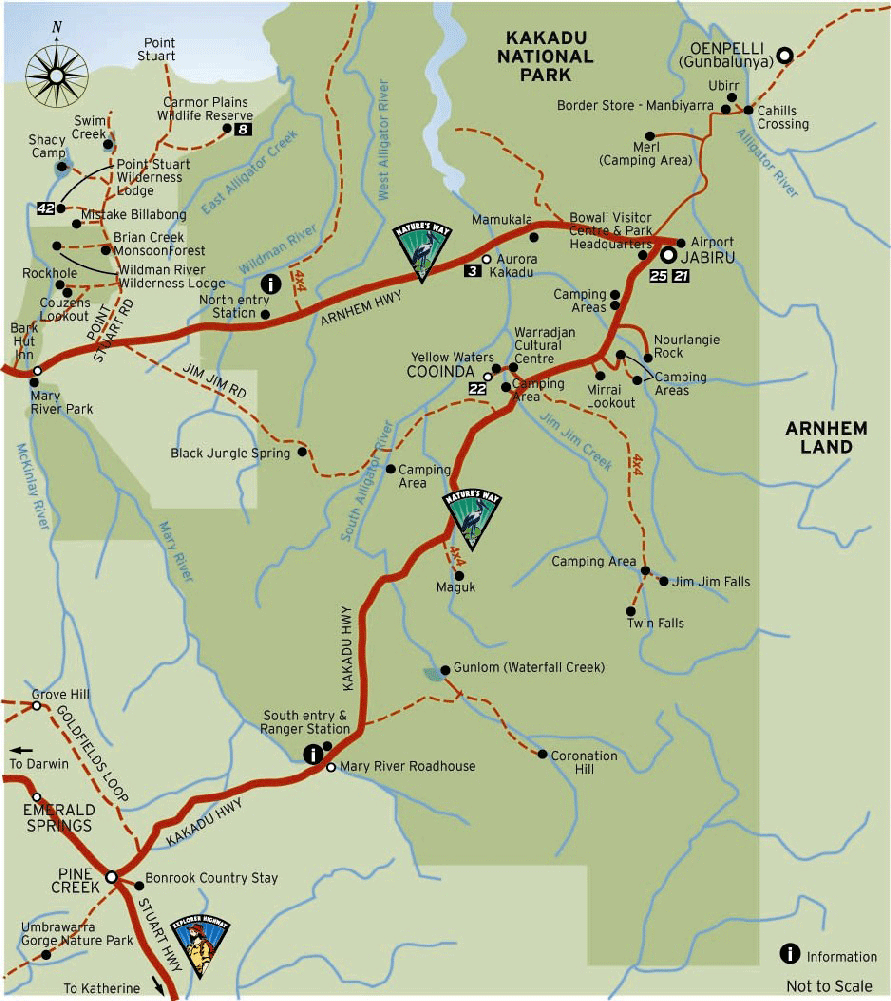
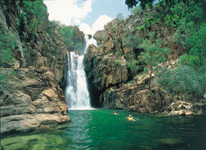
Kakadu National Park an Australian Natural Icon covers almost 20,000 square kms and is 253 kms East of Darwin the capital city of the Northern Territory, Australia. Kakadu National Park is a World Heritage listed area that has been listed for it's cultural and natural heritage and Kakadu is the largest terrestrial national park in Australia. Life in the park does depends on the water, also in respect to the tropical monsoon climate that produces the downpours of the tropical humidity of the "wet" season, and the milder weather of the "dry" season.Kakadu National Park is the gateway to Arnhemland. The sealed roads from Darwin to Kakadu is via the Arnhem Highway and from Katherine to Kakadu National Park via the Kakadu Highway. The Bowali Visitor Centre near Jabiru in Kakadu National Park is located 253 km from Darwin in Northern Territory Australia via the Arnhem Highway entrance. If travelling by road, you should allow 3 hours travelling time from Darwin.
Kakadu is the second largest national park in the world and and is home to approximate number of species: Mammals: 62, Reptiles: 123+, Birds: 280, Freshwater Fish: 51, Insects: 10,000, Frogs: 25, Plants: 1,275. (many are rare and occur only in Kakadu)
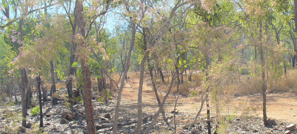
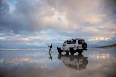
Search Darwin 4wd camper hire Search Darwin 4wd car and camping gear hire Search Darwin campervan hire Search Darwin motorhome hire Car hire AustraliaJim Jim unsealed track Kakadu Garnamarr Campground Jim Jim Falls Region Kakadu National Park Australia Hike bushwalk trek to Jim Jim Falls Gorge Kakadu National Park Guide Areas near Jim Jim Falls Kakadu National Park Australia
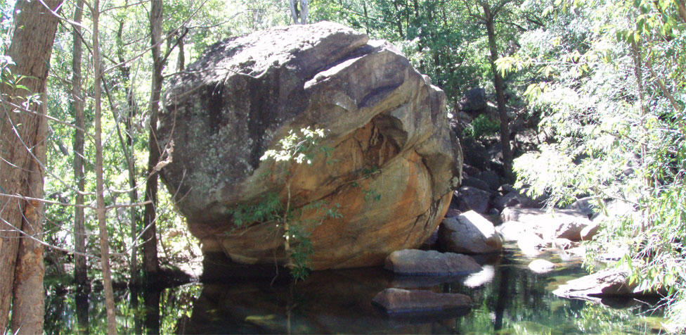
How to get to Maguk, Moline Rockhole, Gubara, Motorcar Falls, Gunlom falls, Koolpin Gorge Twin Falls Kakadu National Park Australia
Things to do in Darwin Darwin travel guide about darwin city
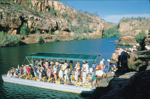
Crocodile cruises Darwin and Kakadu Sightseeing cruises from Darwin Jim Jim Falls Crocodile Facts Jim Jim Falls Crocodile information
Map of Kakadu National Park Northern Territory Australia Protect Kakadu when you visit Kakadu Seasons in Kakadu National Park Australia Travelling Arnhem Highway from Darwin to Jabiru in Kakadu National Park Warradjan Aboriginal Cultural Centre Kakadu National Park
Links tours travel selfdrive Kakadu National Park and Darwin
Cutta Cutta Caves Mataranka Springs Mataranka Falls Mataranka Bitter Springs
Jatbula Trail Edith Falls Crystal Falls
Nitmiluk National Park Southern Rockhole Edith Falls
Douglas Hot Springs Umbrawarra Gorge Butterfly Gorge
-
Kakadu National Park seasons
But Australia's Kakadu sees seasons of varied extremes -- so varied, in fact, that the park's longtime aboriginal inhabitants have divided the year into six distinct seasons.
Gunumeleng Pre-Monsoon Storm Season
Gunumeleng, from mid-October to late December, may in fact last from a few weeks to several months. It is the pre-monsoon season of hot weather that becomes more and more humid. Thunderstorms build in the afternoons and scattered showers bring a tinge of green to the dry land. As the streams begin to run, acidic water that washes from the floodplains can cause fish to die in billabongs with low oxygen levels. Waterbirds spread out as surface water and new growth become more widespread. Barramundi move from the waterholes downstream to the estuaries to breed. This was when Bininj/Mungguy moved camp from the floodplains to the stone country, to shelter from the violent storms of the coming wet season.
Gudjewg - Monsoon Season
Gudjewg, from January to March, can be described as the 'true' wet season. It is a time of thunderstorms, heavy rain and flooding. The heat and humidity generate an explosion of plant and animal life. Spear grass grows to over 2 metres tall and creates a silvery-green hue throughout the woodlands. Magpie geese nest in the sedgelands. Flooding may cause goannas, snakes and rats to seek refuge in the trees. Eggs and stranded animals are a good food source for Bininj/Mungguy during this time.
Banggereng - Knock 'em down storm Season
Banggerreng, in April, is the season when the rain clouds have dispersed and clear skies prevail. The vast expanses of floodwater recede and streams start to run clear. Most plants are fruiting and animals are caring for their young. Violent, windy storms early in this season flatten the spear grass; they are called 'knock 'em down' storms.
Yegge - Cooler but still humid Season
Yegge, from May to mid-June, is relatively cool with low humidity. Early morning mists hang low over the plains and waterholes. The shallow wetlands and billabongs are carpeted with water lilies. Drying winds and flowering Darwin woolly butt tell Bininj/Mungguy that it is time to start burning the woodlands in patches to 'clean the country' and encourage new growth for grazing animals.
Wurrgeng - Cold Weather Season
Wurrgeng, from mid-June to mid-August, is the 'cold weather' time; humidity is low, daytime temperatures are around 30°C and night-time temperatures are around 17°C. Most creeks stop flowing and the floodplains quickly dry out. Burning continues, extinguished by the dew at night. By day, birds of prey patrol the fire lines as insects and small animals try to escape the flames. Magpie geese, fat and heavy after weeks of abundant food, and a myriad of other waterbirds crowd the shrinking billabongs.
Gurrung - Hot Dry Weather
Gurrung, from mid-August to mid-October, is hot and dry. It is still 'goose time' but also time for Bininj/Mungguy to hunt file snakes and long-necked turtles. Sea turtles lay their eggs on the sandy beaches of Field Island and West Alligator Head and goann as rob their nests sometimes. White-breasted wood swallows arrive as thunderclouds build, signalling the return of Gunumeleng.
NT eco adventure tours One day Darwin tours Darwin hotels and resorts Darwin RV camper rentals - 4wd hire
-
Kakadu National Park seasons
The Climate of the Kakadu Region
Kakadu is located in the tropics, 12 to 14° south of the Equator.
The climate is monsoonal, characterised by two major seasons: the dry season and the wet season. The 'build up' describes the transition between these two seasons.
During the dry season (April/May to September), dry southerly and easterly trade winds predominate. Humidity is relatively low and rain is very unusual.
At Jabiru the average maximum temperature for June-July is 32°C. During the 'build up' (October to December) conditions can be extremely uncomfortable with high temperatures and high humidity.
However 'build up' storms are impressive and lightning strikes are frequent. In fact the Top End of Australia records more lighting strikes per year than any other place on earth.
At Jabiru the average maximum temperature for October is 37.5°C.
The wet season (January to March/April) is characterised by warm temperatures and, as one would expect, rain.
Most of the rain is associated with monsoonal troughs formed over Southeast Asia, although occasionally tropical cyclones produce intense heavy rain over localised areas.
At Jabiru the average maximum temperature for January is 33°C.
Annual rainfall in Kakadu National Park ranges from 1,565 mm in Jabiru to 1,300 mm in the Mary River region.
The following charts provide an indication of rainfall, temperatures and humidity within the Kakadu region. Data for the charts was sourced from the Bureau of Meteorology, Darwin.
-
What to do in Darwin
Things to do in Darwin
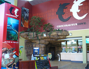
 Crocosaurus Cove Darwin is a great way to spend 1-3 hours if you
have a layover in Darwin or overnight and need a time filler. It's
in the heart of the CBD. If you can't find time to go on a crocodile
cruise and there are many from Darwin then this is the next best
thing that will let you be real close to a live Australian saltwater
crocodile. Crocosaurus Cove is actually Crocosaurus
Cove Aquarium which is modeled after a typical Top End river
system in Northern Territory. I actually liked the display of Australian
Reptiles they had and they displayed some 70+ species of reptiles
truly fascinating as we spent hours and I went round 3 times and
I'm a local here. There are around 180 crocodiles there so they
established a little interaction for you called the 'cage
of death'.
Crocosaurus Cove Darwin is a great way to spend 1-3 hours if you
have a layover in Darwin or overnight and need a time filler. It's
in the heart of the CBD. If you can't find time to go on a crocodile
cruise and there are many from Darwin then this is the next best
thing that will let you be real close to a live Australian saltwater
crocodile. Crocosaurus Cove is actually Crocosaurus
Cove Aquarium which is modeled after a typical Top End river
system in Northern Territory. I actually liked the display of Australian
Reptiles they had and they displayed some 70+ species of reptiles
truly fascinating as we spent hours and I went round 3 times and
I'm a local here. There are around 180 crocodiles there so they
established a little interaction for you called the 'cage
of death'.
-
Kakadu National Park
Kakadu National Park
Kakadu National Park an Australian Natural
Icon covers almost 20,000 square kms and is 257 kms East of Darwin
the capital city of the Northern Territory, Australia. Kakadu
National Park gateway to Arnhemland.The
sealed roads from Darwin to Kakadu is via the Arnhem Highway and
from Katherine to Kakadu
National Park via the Kakadu Highway. Even though access
to kakadu natinal park is sealed it can be flooded in the wet season
on the North Anrhem Highway at the wetlands area. Also Ubirr and
Nourlangie have 2wd access, so does Cooinda and Yellow Water though
the flass and gorges are all 4wd access on unsealed roads and limited
4wd hire operators allow you in see
Australia 4wd Rentals for a good selection of Darwin 4x4 rentals.
-
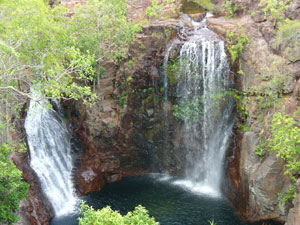
Litchfield National Park
About Litchfield National Park
Together with stunning tropical waterfalls and swimming holes,
this is a truly beautiful destination found just south of Darwin,
the capital city of the Northern Territory. Litchfield National
Park features numerous waterfalls which cascade from a sandstone
plateau called the Tabletop Range, monsoon rainforests, intriguing
magnetic termite mounds and historical sites. Litchfield National
Park is chosen by local Darwin residents and tourists as 1-3 day
destination for it's waterfalls and magnetic termite mounds. Also
noted are the 4WD tracks into some of the more remote parts of Litchfield
National Park and surrounding region. Litchfield National Park lies
approximately 130km's southwest of Darwin near the town of Batchelor
and covers around 1,500 sq km's.
-
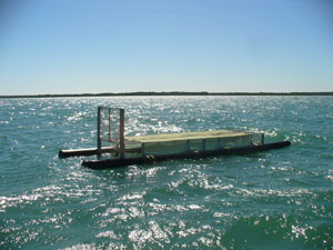
Darwin, Kakadu and Crocodiles
Warnings about crocodiles
How many crocodiles are there in the Northern Territory well its
estimated to be somewhere around 100 000 crocodiles in the wild.
Now protected but once hunted to near extinction around here. Crocodile
skins used to be a major export product from Australia. But always
be aware for the signs
and warning when going to the rivers and parks in the Top End
on crocodiles. Scary well folks did you know that the world’s largest
reptile is our very own Northern Territory Saltwater Crocodile.
The picture is of a crocodile trap in Darwin Harbour. So if you
want to see crocodiles then take a cruise or eco adventure tour
that includes a fresh
water sightseeing cruise.
www.parksandwildlife.nt.gov.au/
-
Nitmiluk National Park
Where is Nitmiluk National Park
Nitmiluk
National Park was also before as Katherine
Gorge and still referred to it as both names. Katherine
Gorge approx. 356klm south of Darwin on the Stuart Highway and
passing some really interesting outback towns such as Pine Creek
and Adelaide River. Adleaide River is located on the Stuart Highway,
150 kilometers south of Darwin, Hayes Creek is a gateway to World
War II sites and the Northern Goldfields loop with easy access to
Litchfield National Park, Batchelor, Pine Creek and the Tjuwaliyn
(Douglas) Hot Springs Park. The most comfortable months to visit
the Park are from May to September. The wet season causes flooding
of the Katherine River and restrictions on some of the activities
available. The picnic area provides gas barbecues, picnic furniture
and toilet facilities. With launch tour boat jetty and canoe hire.
A public swimming area is provided in the picnic area.
NT eco adventure tours One day Darwin tours Darwin hotels and resorts Darwin RV camper rentals - 4wd hire
-
About Us
About us and this web site
We are a small long time based Darwin business locally owned and operated
travel agents specializing in eco soft adventure tours for the mid
to premium guided tours from Darwin. We built this as being Darwin
based we know most of the locals and tourism operators over the last
25 years and have seen many start from their very first tour. So as
we have large clientele I built this and other sites for our booked
clients to get a feel of
what to see and do around tropical Darwin. We also under our brand
name Australia 4 Wheel Drive Rentals specialize in the booking of
4wd cars and 4wd campers along with medium to premium RV motorhome
and campervan rentals from 2, 4 or 6 berth. I began in this industry
in the early/mid 90's and eventually became regarded as the oldest
dedicated specialist agents for 4wd cars, 4wd campers and premium
campers for Australia but especially for Northern Territory. Facebook
4WD Rentals who best to go to than someone regarded as the oldest
specialist 4wd camper dedicated agent in the system us.
NT adventure tours 1 day Darwin tours Darwin accommodation Darwin camper hire - 4wd hire
-
Kakadu and Litchfield eco tours
About guided eco adventure experiences from Darwin
Darwin is the starting or departing point for most Darwin based
adventure tour companies and safaris. What
is the difference between a safari and tour. We have over 300
tours listed thru us and with 1000's of travelled and happy memorable
occasions for our clients our suppliers know we are experts in this
industry and we can offer you greater service and even protection
than booking direct by it's not just you we represent 1000's of
clients to our suppliers and there is power in numbers. Way
outback tours and Adventure
tours from Darwin.
NT adventure tours 1 day Darwin tours Darwin backpackers Darwin camper and 4wd hire
-
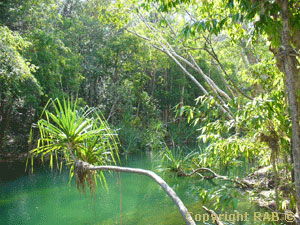
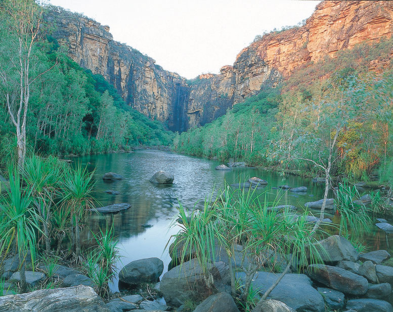
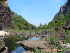
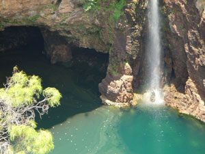
Kakadu gorges, rockholes, falls and pools
Kakadu National Park
Kakadu is in Northern Territory Australia
- also Maguk,
Moline
Rockhole, Gubara,
Motorcar
Falls, Gunlom
Falls and the secretive only a limited number of
permits to the publlic available
Koolpin Gorge. This is all four wheel drive access on unsealed
roads and remote so you will need a large 4wd. We can assist you
book a 4wd Darwin rental and help assist you with your planning.
Most of these waterfalls including Jim Jim Gorge falls and Twin
Falls are situated in the south of Kakadu off the Kakadu Highway.
Jim Jim falls and Twin Falls 4wd access track on the same track
and branches out some distance before the two falls.
NT eco adventure tours One day Darwin tours Darwin hotels and resorts Darwin RV camper rentals - 4wd hire
-
Outback waterholes and falls Katherine
Apart from Kakadu travel south to the Katherine region
See the Southern Rockhole, Mataranka Springs, Bitter Springs, Edith
Falls and the pristineNitmiluk
National Park just 24klm down Maud Creek road before Katherine.
There are so many natural wonders around the top end of Northern
Territory well there is too many to list here. But whether your
in a 2wd or 4wd we can help you plan a family kakdu and katherine
vacation in either a self drive motorhome rental from Darwin return
or oneway to a range of fully guided soft eco adventure tours from
Darwin.
NT eco adventure tours One day Darwin tours Darwin hotels and resorts Darwin RV camper rentals - 4wd hire
-

Darwin car hire
About Darwin car rentals
Darwin e small, compact and large car hire options are cost effective
vehicles to hire and offer return or oneway rentals for 5 people.
We also have 8 seat people movers for that large family or group
of friends to travel around the country and enjoy the vast Australian
landscape.
Darwin car hire Darwin SUV hire Darwin 8 seat hire -
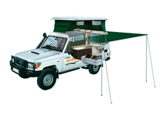
Darwin 4wd campers
About Darwin 4x4 hire
Four wheel drive off road campers for 4 with double rood top tent
and 5 berth campers. We also offer 5 seat 4wd wagons with ground
camping gear and 2 and 3 berth four wheel drive pop top campers
for hire oneway or return hire. Facebook
4WD Rentals
Rooftop tent camper Darwin 4wd car hire Darwin 4x4 poptop campers Darwin 4wd car and camping gear hire -
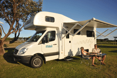
Darwin motorhome hire
About Darwin RV motorhome hire
Darwin motorhome self drive hire and campervan rentals offer you
from older budget brands to premium quality 1-2 year Maui RV motorhome
hire from Darwin. We have budget, family and premium brands for
up to 6 adults travelling.
Darwin premium RV motorhome hire 2 Berth 4 Berth 6 Berth